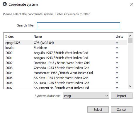
Coordinate System Selection
The choice of a coordinate system is organized by country of origin or commonly used ID.
The chosen coordinate system determines the project's units of measurement.
RealityCapture is shipped with the EPSG database and a local database with Euclidean coordinate system.
- To import the local database click the import button and locate local.xml in the application installation folder.
You can create your own coordinate systems easily by editing/adding database files (a properly formatted xml file).
- Your most recently used coordinates systems appear first in the dialog.
- Search for a coordinate system by entering key words into the search edit field, e.g. "WGS 84".
Project and Export Coordinate Systems
RealityCapture allows using more different coordinate systems at once. Even every ground control point can be measured with respect to a different coordinate system.
However, there is a global project coordinate system which is used as a reference for measuring, displaying coordinates or accuracy reports.
- To set a project coordinate system, go to WORKFLOW / Settings / Coordinate Systems / Project coordinate system.
- To export a model / mesh in a different coordinate system, go to WORKFLOW / Settings / Coordinate Systems / Output coordinate system.
Some export tools allows defining an export coordinate system directly in their export settings dialogs.
TIP: It is advisable for all
control points to be in the same coordinate system as conversions may bring small inaccuracies.