Flight Log Import
A flight log is a record of a particular flight with use of a GPS device to track the position of a plane or camera during image taking.
If you have a flight log file (txt format), you can import it in your RC project and geo-reference/scale the model with a few clicks of your mouse.
- First, make sure you have set the project coordinate system to the one which the "to-be-imported" flight logs are in.
The Application Settings are found in the Application part of the WORKFLOW tab under
Coordinate systems / Project coordinate system.
- Now go to WORKFLOW / Flight Log and browse a flight log file.
- Flight log can also be imported using the command line.
Import Dialog
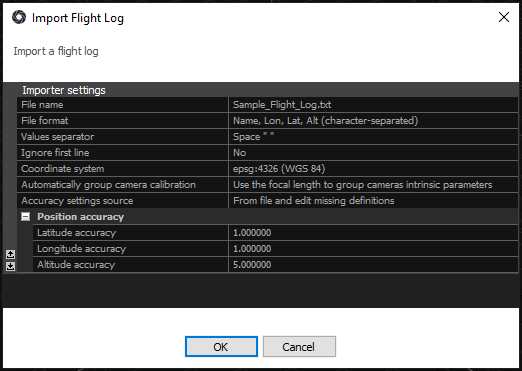
An import dialog will appear immediately. Let us have a look at the options in the import dialog window:

- File name - name of a file containing the flight log of cameras
- File format - defines order and type of the values in a flight log
- Values separator - separator used to separate the values found in a flight log file. Qualifiers are also supported which means that you can place each field in double quotes ("") to signify that it is the same field.
- Ignore first line - if file contains a header, RealityCapture can ignore the first line of the file. Lines that begin with symbol # are automatically skipped.
- Coordinate system - define the coordinate system in which the position of the cameras is defined
- Automatically group camera calibration - you can group all cameras from a flight log into the same group or assign groups based on the focal length. Alternatively, you can choose not to group cameras.
- Accuracy settings source - from file and edit missing definitions – accuracies from a file are taken and the missing ones are set manually in the Position Accuracy.
Global camera priors setting – accuracy for all parameters is defined in the Alignment settings.
-
You can choose from various text file formats provided by RealityCapture.
Advanced users can easily define their own formats, different values separator, comment symbol or qualifiers by modifying the flightlogs.xml in the application installation folder.
You can find the instructions on how to edit the flightlogs.xml as well as the list of supported values for import here.
HINT: Lon - longitude, Lat - latitude, Alt - altitude
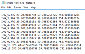
A sample of a Name, Lon, Lat, Alt (character-separated) flight log file format with space-separateded values:

See also:
- Learn how to use RealityCapture with different full-body scanners click here
- Read more about coordinate systems click here

