Ground Controls Export
In RealityCapture (RC) you can easily import and export ground control points (GCPs). This page should guide you how to export ground control points into a text file.
- Be aware that RC will export only the selected control points. To export all ground controls, leave the control points unselected.
- Go to ALIGNMENT / Export / Ground Control.
- Fill in a file name and select a file type.
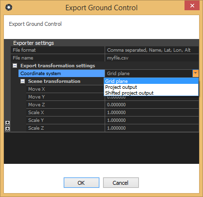
- Press the Save button and the Export Ground Control dialog will appear (see the picture below).
- Select the export coordinate system in the settings panel.

- Press OK to export.
NOTE: This option is available only if you have at least one control point in your project.
- Ground control points can be exported also using the command line.
Export Settings
- File Format:
RC supports several different types of csv files. A complete list of the export file formats is stored and defined in controlpoints.xml as simple scripts.
Advanced users can easily modify or create their own format.
To export measurements of control points, use the $ExportControlPoints(...) function and inside the brackets put everything which should be printed for each measurement.
The expansion system will automatically substitute variables/terms inside the brackets starting with a dollar sign ($). Everything else will be left untouched like it is, including new lines.
Example script:
$ExportControlPoints($If( isGroundControl,$(name), $(alt:g)
))
The script above will export the name and altitude of each control point whose type is set to 'Ground control' or 'Ground test'.
Here is an example of the output:
gcp0, 1345.21
gcp1, 964.36
gcp2, 1512.24
Supported tokens:
| Token |
Description |
Type |
| index |
Index of a control point |
Integer |
| name |
Name of the control point |
String |
| x |
X - coordinate of a ground control point |
Double |
| y |
Y - coordinate of the ground control point |
Double |
| z |
Z - coordinate of the ground control point |
Double |
| lat |
Latitude of the ground control point |
Double |
| lon |
Longitude of the ground control point |
Double |
| alt |
Altitude of the ground control point (identical with z) |
Double |
| isGroundControl |
True if the type of a control point is 'Ground control' or 'Ground test' |
Boolean |
- Coordinate system:
Each ground control point has its own coordinate system and the exporter transforms coordinates from this coordinate system to the one selected in the panel of export settings.
Supported coordinate systems are:
- Grid plane What you see in the 3D view.
- Project output This coordinate system is defined in the Application Settings under Coordinate Systems. To open application settings, go to the workflow tab / Settings.
- Shifted project output Same as above, but shifted in a specified direction.
